|
<< Click to Display Table of Contents >> Point pressure (Mogi) |
  
|
|
<< Click to Display Table of Contents >> Point pressure (Mogi) |
|
This panel is intended to set the parameters for the elastic Point Pressure source, according to the formulation of Mogi [1958]
Technical Note
The Point Pressure source is a simple model used to predict the surface displacement induced by the pressure variation in a point buried in an elastic half-space. Despite its simplicity, it is largely used to model the deformations induced by the magma chamber activity or those caused by fluid or gas injection or extraction. The point-source approximation can be reasonable, provided that the real source dimension is enough smaller than its depth (Fig. 1).
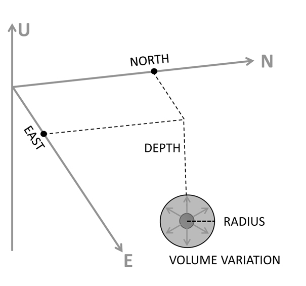
Figure 1. Mogi source
Given the relationship between the pressure change and the volume change, we adopt the volume notation which is more intuitive and coherent with the Elastic dislocation source. As for the other sources, the Point Pressure parameters to set differ according to the specific processing: Non-Linear Inversion, Linear Inversion, Forward Modeling, CFF Stress Transfer or Calculate and Draw Focal Mechanism.
Unlike the other panels, in the Non-Linear Inversion the user must set a range value (minimum/maximum) for the source parameters shown in Fig. 1. When the maximum and minimum value are equal, that parameter is considered fixed and not inverted.
About topographic corrections. The analytical model allows to calculate the displacement at the surface of the elastic half-space. This condition is acceptable when the source depth is considerably higher than the elevation above the sea level of a point where the displacement is calculated. However, it could happen that the topography for a given area is comparable with the source depth; in this case the point vertical distance from the source is significantly higher than the source depth. The strategy adopted to account for this elevation is to sum the source depth and the point elevation when calculating the point displacement (Fig. 2) [Lungarini et al., 2005]. When creating the InSAR dataset through the Image Subsampling tool, it is possible to add the elevation for every point to allow the use of the "Apply Topographic Corrections" option.
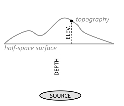
Figure 2. Source depth and point elevation composition in modeling
Input Parameter(s)
Volume variation
Source volume variation, expressed in meters^3.
Depth
Source depth, positive downward, in meters.
East, North
coordinates of the point source, in a projected cartographic system (UTM-WGS84 is suggested)
Linear inversion input options
Variable Volume
Volume variation is is retrieved by inversion
Positive Variable Volume
Positive volume variation is retrieved by inversion
Negative Variable Volume
Negative volume variation is retrieved by inversion
Fixed Source
No parameters are retrieved by inversion, and the source contribution to the displacement is considered as it is (it can be used only if other sources to invert are present).
Ancillary Parameters
'mu' Lame's constant, 'lambda' Lame's constant
Lame's constant of the elastic medium (see Preferences).
Compensate topographic corrections
Setting the flag, the processing is carried out with topographic corrections (see the Technical Note and Fig. 2).
Specific Function(s)
Draw Source in ENVI Display
Draw the source in the ENVI view.
General Functions
Add/Commit
End the source parameter editing of a new source (Add) or an existing one (Commit).
Cancel
The window will be closed.
Help
Specific help document section.
References
Lungarini, L., Troise, C., Meo, M. and G. De Natale (2005) Finite element modelling of topographic effects on elastic ground deformation at Mt. Etna, J. Volc. Geo. Res., 144,, 257-271, doi: 10.1016/j.jvolgeores.2004.11.031
Mogi, K. (1958), Relations between eruptions of various volcanoes and the deformation of the ground surface around them, Bull. Earth Res. Inst., 36, 99–134.