|
<< Click to Display Table of Contents >> Basic Module - Feature Extraction - Enhanced-DPSVI |
  
|
|
<< Click to Display Table of Contents >> Basic Module - Feature Extraction - Enhanced-DPSVI |
|
Purpose
This tool allows to compute an Enhanced Dual Polarization SAR Vegetation Index (EDPSVI) using Dual-Pol data (HH+HV or VV+VH). It estimates the land cover based on the amount of vegetation.
Technical Note
The EDPSVI is an improved version of the DPSVI in Periasamy (2018).
One or more SAR dual-pol acquisitions can be used as input; each date is analyzed independently and one EDPSVI is generated as output for each date.
This tool allows to exploit the coherence information: the coherence between two images is used to rescale the results of the vegetation index. Indeed, the Dual Polarization SAR Vegetation Index (which is based on intensity data only) shows high values on targets despite of vegetation absence, e.g. bare soil and rocky terrains. Using the coherence, which reaches high values on stable and strong scatterers, the EDPSVI is properly improved. This eventually means low EDPSVI values on sparse or not vegetated land, independently from soil roughness.
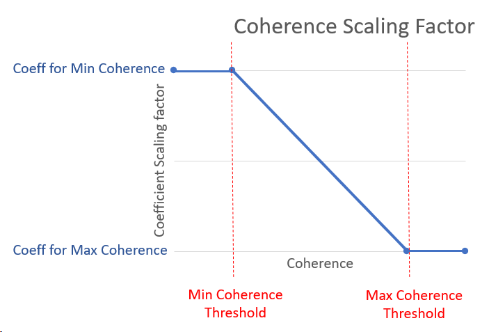
The relationship between coherence and coherence scaling factor is described in the graph below. Thresholds for scaling factor coefficient at minimum coherence and maximum coherence are used. The higher the coherence values the lower the rescaling factors.
The EDPSVI is computed on single dates even though multiple dates can be used.
Note: this rescaling is applied only to the EDPSVI dates corresponding to the Secondary acquisitions of the InSAR coherence pairs.
Normalization factor
Enter ''0'' not to carry out any normalization. In this case the output will not be converted to unsigned byte.
Scale factor
Increasing this value implies a faster saturation of the EDPSVI, whose output range goes from 0 to 100.
As an example, all values from 50 to 100 with Scale Factor=20, they will all be equal to 100 with Scale Factor=40. All values from 0 to 50 with Scale Factor=20, they will be doubled with Scale Factor=40.
Input Files
Input file list
Input file list of the geocoded (_geo) single or multi-temporal Dual-Pol Intensity data (values have to be in linear scale). This file list is mandatory.
Optional Files - Principal Parameters
Coherence File List
The geocoded coherence file previously computed on the same temporal interval (Multi-temporal Coherence). The coherence must be computed between the pair of VV polarized images.
Parameters - Principal Parameters
Copol Max Value [dB]
Maximum backscatter value set for the analyzed stack of images; it is useful in case different stacks need to be compared. If this value is not set, it is computed automatically based on the input data stack.
Scale
Scaling factor that scales the EDPSVI values in a range between 0 and 1. Values higher than 1 or lower than 0 are acceptable.
Normalization Factor
By setting this value the output is rescaled in a range between 0-100 to obtain the corresponding Byte values. The set normalization factor corresponds to 100. It has to be modified according to the used Scale value.
Min Coherence Threshold
Minimum coherence value to apply the coefficient for Min Coherence. All values below this threshold are considered equal and the "Coeff at Min Coh" will be assigned.
Max Coherence Threshold
By setting this flag the output pixel value represents the average calculated from all input data. All values above this threshold are considered equal and the "Coeff at Max Coh" will be assigned.
| Coefficient for Min Coherence |
Coefficient that defines the coherence scaling factor for the coherence value lower or equal than the Min Coherence Threshold.
Coefficient for Max Coherence
Coefficient that defines the coherence scaling factor for the coherence value greater or equal than the Max Coherence Threshold.
Parameters - Global
It brings to the general section of the Preferences parameters. Any modified value will be used and stored for further processing sessions.
Parameters - Other Parameters
It brings to the general section of the Preferences parameters. Any modified value will be used and stored for further processing sessions.
Output Files
Output Root Name
Output root name of the selected feature(s). This root name is mandatory.
_EDPSVI
Enhanced Dual Polarization SAR Vegetation Index for each dual-pol input file and the corresponding .sml, .hdr.
Details specific to the Units of Measure and Nomenclature of the output products can be found in the Data Format section.
General Functions
Exec
The processing step is executed.
Store Batch
The processing step is stored in the batch list. The Batch Browser button allows to load the batch processing list.
Close
The window will be closed.
Help
Specific help document section.
Specific Function(s)
None.
Task, SARscapeBatch object, SARscapeBatch script example
References Periasamy Shoba (2018): "Significance of dual polarimetric synthetic aperture radar in biomass retrieval: An attempt on Sentinel-1." Remote Sensing of Environment 217, 537-549.