|
<< Click to Display Table of Contents >> Interferometric Stacking - PS & E-PS - Overview |
  
|
|
<< Click to Display Table of Contents >> Interferometric Stacking - PS & E-PS - Overview |
|
A Note on the Persistent Scatterers functionality
It is conceived for the generation of products aimed at monitoring the temporal evolution of surface deformations.
The technique, extending SAR Interferometry to the analysis of large sets of multi-temporal acquisitions, enables to improve the measurement accuracy from few centimetres (classical Interferometry approach) to few millimetres (Persistent Scatterers approach). In addition to that, limitations typical of SAR Interferometry (i.e. atmospheric distortions or temporal de-correlation) are dramatically reduced.
The use of large temporal series enables to improve the identification and further removal of atmospheric related effects (artifacts) by means of a dedicated space-time filtering operation. A minimum number of three acquisitions is required to be able to run the processing, but more (at least twenty) are suggested to get reliable results especially in case of low coherence conditions.
The ScanSAR module specific license allows processing ScanSAR data.
The output products are stored in step-specific folders, which the program creates during the processing execution. These folders are automatically created inside the root output directory named using, as prefix, the "Output Root Name" and "_PS_processing" as suffix, which is entered in the first processing step.
All intermediate files generated from each step are stored inside the _PS_processing/work sub folder. In order to avoid processing failures it is recommended not to move any file from its original repository folder.
The name of the project can not be modified once the Connection Graph step has been executed. The manipulation of the original name could lead to unexpected behaviors.
The "Auxiliary file" (marked by the name auxiliary.sml) is saved in the root output directory and it is updated during the execution of the different processing step. From the Interferometric Process step onwards, throughout the whole processing chain; it is important to note that the first input to enter, in any processing panel, is the "Auxiliary file". This file contains information to understand which steps have been executed, and what are the products generated.
The "work_parameters.sml" is saved in the work sub folder and contains information about the processing parameters setting.
It is possible to copy the whole [rootname]_PS_processing folder together with the input and DEM files to another location/another drive (e.g. if the disk is full). The process can be resumed from the break point simply by re-launching the Connection Graph (inserting the inputs in the new location). Once the new Auxiliary file has been created it is necessary to edit it by inserting the DEM path in the new location and setting to "OK" or "NotOK" according to the steps performed in the previous location.
It is important to know that constant displacements, which affect all the area in the observed "Geographical Region", are not detected.
Notes:
•Please do not create your results in a folder containing spaces in the path.
•Once the output is created, the maximum number of files that can be opened is 130 due to the open capabilities files number of files opened in Windows (130x3 considering all the auxiliary files for single shape as .shp, .shx, .dbf). If the value exceeds 130, the process may slow down.
•In order to avoid processing failures it is recommended not to move any file from its original repository folder.
•The name of the project can not be modified once the Connection Graph step has been executed. The manipulation of the original name could lead to unexpected behaviors.
Enanched - Persistent Scatterers functionality
The Enhanced - Persistent Scatterers technique identifies Distributed Scatterers and Permanent Scatterers pixels to improve the InSAR pixel coverage over rural areas by implementing adaptive filtering on the interferometric phase. This approach is inspired by the works of Ferretti (2011) and Fornaro (2015). The joint processing of PS and Distributed Scatterers (DS) can be performed independently.
The processing sequence is shown in the following block diagram:
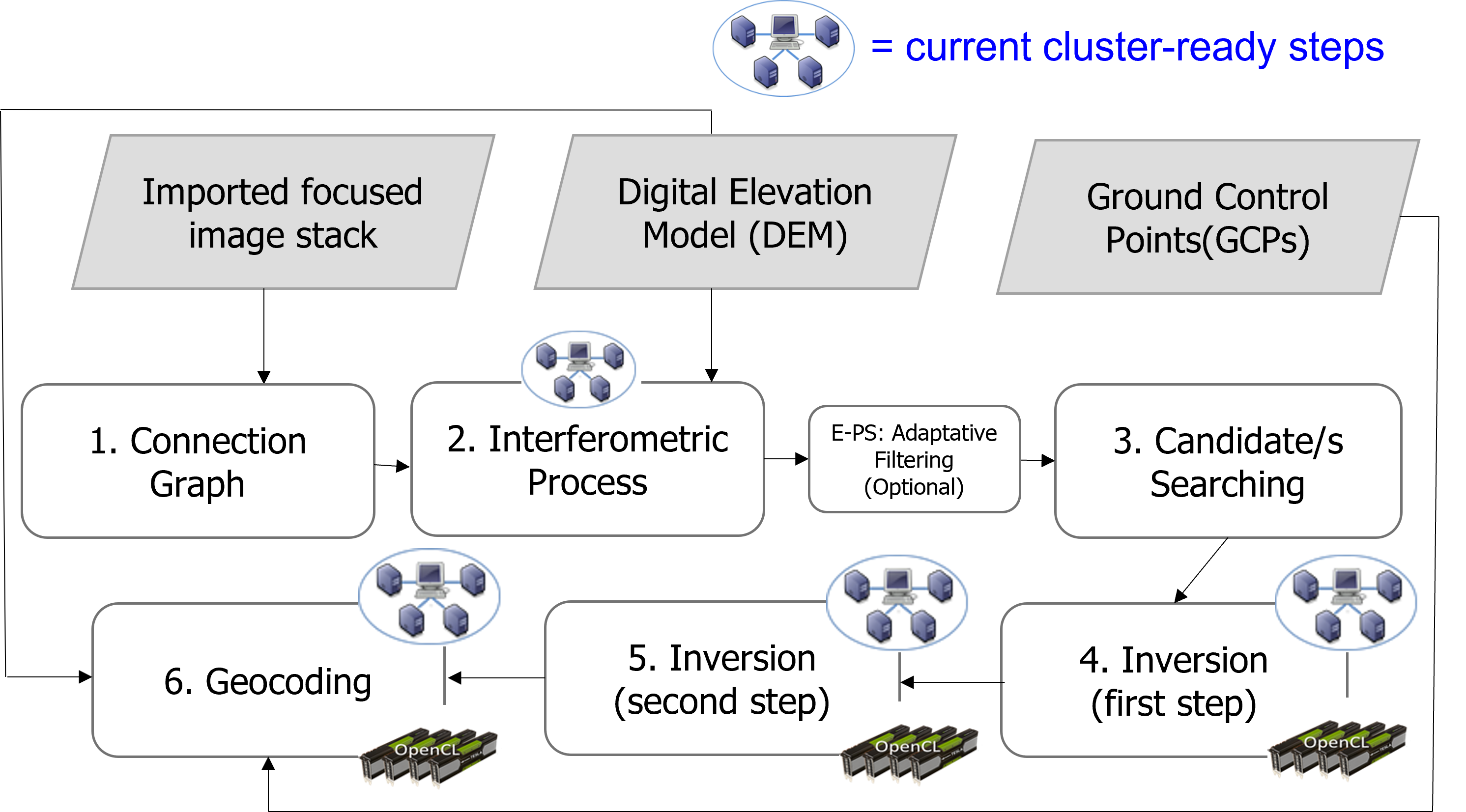
1) Connection Graph
All images are connected to create a network of Reference and Secondarys pairs, which are linked each other only whether the baseline values are within the input thresholds. All data will be coregistered onto a Reference acquisition, which can be automatically identified by the program or manually selected by the user.
2) Interferometric Workflow
The flattened interferograms (and related SAR intensity images), together with the intensity images are generated.
E-PS (Optional Step)
The filtered inteferograms, generated through the application of an adaptive filter, are generated.
3) PS First Inversion
The first displacement (date by date value), velocity and height (correction values ) related products are generated without removing any phase component due to the atmosphere;
4) PS Second Inversion
The atmospheric corrections, related to spatial and temporal variations, are performed in this step; then this component is estimated and finally subtracted from the interferogram files in order to generate the final displacements.
5) Geocoding
All PS related products (e.g. displacement velocities, residual heights, displacement time series, kml and shape files, etc.) are projected onto the cartographic system of the input "DEM file".
It is possible to get two kind of output formats: Raster and Shape.
Regarding the raster format, the displacement measurements can be re-projected onto a vertical and slope direction.
Note that:
–SAR data must be imported (see Basic module).
–SAR RAW products must be imported and focussed (refer to Focusing Module ).
–Default setting for selected parameters can be specified in the Preferences panel.
–The SAR Tutorial, which includes basic knowledge on SAR theory and data processing, complements the online help.
–Data geocoded to GEO-GLOBAL cartographic reference system can be automatically displayed into the Google Earth environment by double clicking on the output .kml file.
–Co-ordinate decimal values must be entered using the dot (e.g. 29.30) and not the comma (e.g. 29,30) character.
Cluster Operation Mode
If a cluster license is available, and the Use Cluster flag is set (see Cluster Preferences), the most time consuming steps will be carried out on multiple processing nodes. These steps include image stack co-registration, interferogram formation, as well as the Inversion (First and Second Inversion) and the Geocoding of the results. Before running the application in cluster mode it is recommended to carry out the connection test. Progress can be monitored via the progress bar and the dedicated cluster monitoring tool.
References
A. Ferretti, C. Prati and F. Rocca: "Nonlinear subsidence rate estimation using permanent scatterers in differential SAR interferometry". Geoscience and Remote Sensing, IEEE Transactions on, vol. 38, no. 5, Part 1, Sept. 2000, pp. 2202 - 2212.
A. Ferretti, C. Prati and F. Rocca: "Permanent scatterers in SAR interferometry". Geoscience and Remote Sensing, IEEE Transactions on, vol. 39, no. 1, Jan. 2001, pp. 8 - 20.
A. Hooper, H. Zebker, P. Segall, and B. Kampes: "A new method for measuring deformation on volcanoes and other non-urban areas using InSAR persistent scatterers". Geophysical Research Letters, vol. 31, December 2004.
A. M. Guarnieri and S. Tebaldini, "On the Exploitation of Target Statistics for SAR Interferometry Applications," in IEEE Transactions on Geoscience and Remote Sensing”
A. Ferretti, A. Fumagalli, F. Novali, C. Prati, F. Rocca and A. Rucci, "A New Algorithm for Processing Interferometric Data-Stacks: SqueeSAR," in IEEE Transactions on Geoscience and Remote Sensing.
Fornaro, Gianfranco, et al. "CAESAR: An Approach Based on Covariance Matrix Decomposition to Improve Multibaseline-Multitemporal Interferometric SAR Processing." IEEE Transactions on Geoscience and Remote Sensing 53.4 (2015): 2050-2065.Lin, K.-F.