Accuracy Assessment Background
The RPC Refinement panel reports various error statistics for individual GCPs and the entire RPC model. The table under the GCPs tab lists map coordinates, height above the WGS-84 ellipsoid, and image coordinates for each GCP. Following this are some fields with predicted error statistics for each point:
- Error X: The difference in eastings (in meters) between the GCP and image location. Values can be positive or negative.
- Error Y: The difference in northings (in meters) between the GCP and image location. Values can be positive or negative.
- Error Z: The difference in meters between the Height value of the GCP and the corresponding DEM height above the WGS-84 ellipsoid.
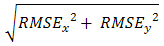
- Error Magnitude:
 in meters. Values are always positive.
These error statistics do not represent absolute accuracy, with reference to ground locations. Instead they are relative to the accuracy of the GCPs used for accuracy estimation. The Joint Research Centre (2008) recommends that GCPs are at least three times (five times is recommended) more precise than the target specification for the orthorectified image. For example, if the target specification is 2.5 meters RMSE, the GCPs should have a relative accuracy of 0.8 meters RMSE or better.
Horizontal Accuracy
The Horizontal Accuracy value under the GCPs tab is the horizontal root mean square error (RMSE), calculated as:
Where:
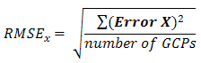
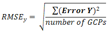
The Error X and Error Y values for each GCP are reported in the RPC Refinement panel.
The Horizontal Accuracy value will change based on whether or not you choose to compute all GCPs under the Statistics tab.
The GCP Statistics options under the Statistics tab give you a choice of how the Horizontal Accuracy predicts the accuracy of the orthorectified image.
- All: The estimated accuracy using both adjustment GCPs and independent GCPs.
- Adjustment GCPs: The estimated accuracy using only adjustment RPCs.
- Independent GCPs: The estimated accuracy using only independent GCPs.
With one or two adjustment GCPs, the RPCs are adjusted using an image-space translation. With three or more adjustment GCPs, the RPCs are adjusted using an image-space RST.
The following statistics are related to horizontal accuracy:
- CE95: The circular standard error at the 95% confidence level:

See FGDC (1998) for details. For the most accurate CE95 value, you should have at least 20 GCPs.
- RMSE X: The root mean square (RMS) difference in eastings (in meters) between the GCP and image location. See the equation above.
- RMSE Y: The RMS difference in northings (in meters) between the GCP and image location. See the equation above.
- RMSE R: The horizontal RMSE; same as the Horizontal Accuracy value.
- The Number of GCPs shows how many GCPs were used in calculating the statistics.
Vertical Accuracy
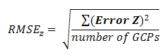
The RMSE Z value is calculated as follows. The Error Z values for each GCP are reported in the RPC Refinement panel.
The LE95 value is the difference (in meters) between the GCP-measured elevation and the DEM elevation with an optional geoid offset. It is also known as the linear error at the 95% confidence level:

Outlier Thresholds
Use the options in the Error Overlay drop-down list to set the threshold at which outlier GCPs are identified in the error overlay image.
- 3 x RMSE [X or Y]: By default, white areas in the error overlay represent GCPs with three times the RMSE X or RMSE Y value. These GCPs are marked with a
 or
or  icon. Green icons represent GCPs that will be used to adjust the RPC model. These points are called adjustment GCPs and are marked with green crosshairs in the image display. Grey icons represent GCPs that will not be used to adjust the RPC model. These points are called independent GCPs and are marked with grey diamond symbols in the image display.
 - User Defined: You can set your own threshold instead of accepting the default value (which is three times the RMSE X or RMSE Y value). Enter an error magnitude value, in meters, in the Threshold field. GCPs with error magnitude values greater than the threshold will be marked as bright white areas.
Changing the GCP Statistics options will change the outlier results.
Federal Geographic Data Committee, 1998: Geospatial Position Accuracy Standards Part 3: National Standard for Spatial Data Accuracy, FGDC-STD-007.3-1998. Washington, D. C.: Federal Geographic Data Committee. https://www.fgdc.gov/standards/projects/FGDC-standards-projects/accuracy/part3/chapter3. Accessed 08 January 2011.
Joint Research Centre, Institute for the Protection and Security of the Citizen. Guidelines for Best Practice and Quality Checking of Ortho Imagery, Issue 3.0, v.20/10/2008.