User Interface Elements
When writing a custom task, you can choose to display a dialog that lets the end user select input and output parameters for ENVITasks. This topic describes various user interface (UI) elements that you can add to dialogs.
In a style sheet, set the type key to one of these UI elements. For example:
"parameters": [
{
"name": "raster_filename",
"type": "IDLLabel_UI"
}
Some elements have keywords that let you display specific options for the end user to choose. These are described in each section below. For example:
"name": "raster_filename",
"type": "IDLList_UI",
"keywords": {
"OPTIONS": ['Band 1', 'Band 2', 'Band 3', 'Band 4']
}
Or:
"name": "raster_filename",
"type": "ENVIRaster_UI",
"keywords": "MULTIPLE"
To see a preview of a UI element, pass it to the ENVIUI::CreateFromDialog method. You can also set keywords on some elements, as this example shows:
e = ENVI()
UI = e.UI
element = IDLList_UI(OPTIONS=['Band 1', 'Band 2', 'Band 3', 'Band 4'])
result = UI.CreateFromDialog(element)
ENVI Elements
The following UI elements are unique to the ENVI interface. They are listed in alphabetical order.
|
Type |
|
|
Description |
Choose a color table. |
|
Keywords |
None |
|
Example |
|
|
Return Value |
A color table, for example: BLUE = 66, 67, 67, 68, 68, ... GREEN = 1, 3, 6, 8, 11, ... PALETTE = 158, 1, 66, 160, 3, ... RED = 158, 160, 162, 165, 167, ... |
|
Type |
|
|
Description |
Set a color table name. |
|
Keywords |
None |
|
Example |
|
|
Return Value |
A color table name, for example: CB-Spectral |
|
Type |
|
|
Description |
Select a predefined or custom color table. |
|
Keywords |
None |
|
Example |
|
|
Return Value |
A 256 x 3 array of RGB values that define the color table |
|
Type |
|
|
Description |
Enter parameters for a coordinate system. You can use the coordinate system from an existing dataset or from the current view. Or, click the |
|
Keywords |
None |
|
Example |
|
|
Return Value |
An ENVICoordSys object, for example: ENVICOORDSYS <253938> COORD_SYS_CODE = 0 COORD_SYS_STR = 'PROJCS["NAD_1983_UTM_Zone_13N", PRIMEM ["Greenwich",0.0], UNIT["Degree",0.0174532925199433]], PROJECTION["Transverse_Mercator"], PARAMETER["False_Easting",500000.0], PARAMETER["False_Northing",0.0], PARAMETER["Central_Meridian",-105.0], PARAMETER["Scale_Factor",0.9996], PARAMETER["Latitude_Of_Origin",0.0], UNIT["Meter",1.0]]' |
|
Type |
|
|
Description |
This is similar to ENVICoordSys_UI but is meant for capturing a coordinate system string. |
|
Keywords |
None |
|
Example |
|
|
Return Value |
A coordinate system string, for example: PROJCS["NAD_1983_UTM_Zone_13N", GEOGCS["GCS_North_American_1983", DATUM["D_North_American_1983", SPHEROID["GRS_1980",6378137.0,298.257222101]], PRIMEM["Greenwich",0.0], UNIT["Degree",0.0174532925199433]], PROJECTION["Transverse_Mercator"], PARAMETER["False_Easting",500000.0], PARAMETER["False_Northing",0.0], PARAMETER["Central_Meridian",-105.0], PARAMETER["Scale_Factor",0.9996], PARAMETER["Latitude_Of_Origin",0.0], UNIT["Meter",1.0]] |
|
Type |
|
|
Description |
Select an ENVI Feature Counting file. |
|
Keywords |
None |
|
Example |
Use this dialog to select an ENVI Feature Counting file ( |
|
Return Value |
An ENVIFeatureCount object that contains the URI to the ENVIFEATURECOUNT <285284> URI: C:\MyData\Buildings.efc |
|
Type |
|
|
Description |
Select an ENVI Ground Control Point (GCP) file. |
|
Keywords |
None |
|
Example |
Use this dialog to select an ENVI GCP file ( |
|
Return Value |
An ENVIGCPSet object, for example: ENVIGCPSET <297131> COORD_SYS_CODE = 32612 COORD_SYS_STR = 'PROJCS["WGS_1984_UTM_Zone_12N",GEOGCS["GCS_WGS_1984",DATUM["D_WGS_1984",SPHEROID["WGS_1984",6378137.0,298.257223563]],PRIMEM["Greenwich",0.0],UNIT["Degree",0.0174532925199433]],PROJECTION["Transverse_Mercator"],PARAMETER["False_Easting",500000.0],PARAMETER["False_Northing",0.0],PARAMETER["Central_Meridian",-111.0],PARAMETER["Scale_Factor",0.9996],PARAMETER["Latitude_Of_Origin",0.0],UNIT["Meter",1.0]]'
Total GCPs: 14
0: {408620.650000 3698081.000000 314.977000 4365.000000 446.000000 } 1: {406652.050000 3698011.500000 311.083000 3568.000000 478.000000 } etc... |
|
Type |
|
|
Description |
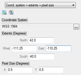
Create a grid definition. |
|
Keywords |
None |
|
Example |
|
|
Return Value |
An ENVIGridDefinition object, for example: ENVIGRIDDEFINITION <256169> EXTENTS = -111.25000, 42.000000, -110.25000, 40.000000 NCOLUMNS = 2 NROWS = 4 SPATIALREF = <ObjHeapVar256172 (ENVISTANDARDRASTERSPATIALREF)> |
|
Type |
|
|
Description |
Select a LAS-format point cloud file. |
|
Keywords |
None |
|
Example |
Use this dialog to select a point cloud file in LAS format. |
|
Return Value |
An ENVIPointCloud object, for example: ENVIPOINTCLOUD <264406> DATA_RANGE = 593741.00, 5289518.0, 334.01000... DIRECT_READ = 0 NPOINTS = 6459297 ... |
|
Type |
|
|
Description |
Enter parameters for a spatial reference object that applies to ENVI point clouds. |
|
Keywords |
None |
|
Example |
Use this dialog to select a point cloud spatial reference. |
|
Return Value |
An ENVIPointCloudSpatialRef object |
|
Type |
|
|
Description |
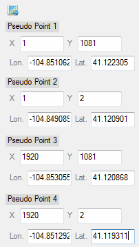
Enter parameters for a pseudo spatial reference. |
|
Keywords |
None |
|
Example |
|
|
Return Value |
An ENVIPseudoRasterSpatialRef object, for example: ENVIPSEUDORASTERSPATIALREF <257560> COORD_SYS_CODE = 0 COORD_SYS_STR = 'GEOGCS["GCS_WGS_1984", DATUM["D_WGS_1984", SPHEROID["WGS_ 1984",6378137.0,298.257223563]], PRIMEM["Greenwich",0.0], UNIT["Degree",0.0174532925199433]]' PSEUDO_GEO_POINT_1 = 1.0000000, 1081.0000, -104.85106, 41.122305 PSEUDO_GEO_POINT_2 = 1.0000000, 2.0000000, -104.84909, 41.120901 PSEUDO_GEO_POINT_3 = 1920.0000, 1081.0000, -104.85306, 41.120868 PSEUDO_GEO_POINT_4 = 1920.0000, 2.0000000, -104.85129, 41.119311 |
|
|
|
|
Description |
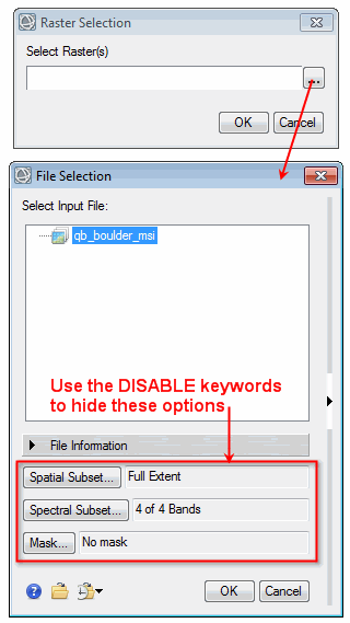
Select an image that is in ENVI raster format. |
|
Keywords |
MULTIPLE: Set this keyword to allow the user to select more than one raster. DISABLE_SUB_RECT: Set this keyword to disable spatial subsetting from the Data Selection dialog. DISABLE_BANDS: Set this keyword to disable spectral subsetting from the Data Selection dialog. DISABLE_MASK: Set this keyword to disable selecting an input mask from the Data Selection dialog. |
|
Example |
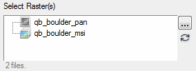
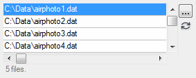
Example with MULTIPLE keyword set:
|
|
Return Value |
An ENVIRaster object or array of ENVIRaster objects, for example: ENVIRASTER <349142> AUXILIARY_SPATIALREF = !NULL AUXILIARY_URI = <Array[2]> DATA_TYPE = 'uint' etc. |
|
Type |
|
|
Description |
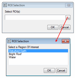
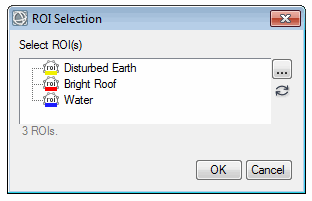
Select one or more regions of interest (ROIs) that have already been opened in ENVI. |
|
Keywords |
MULTIPLE: Set this keyword to allow the user to select more than one ROI. |
|
Example |
Example with MULTIPLE keyword set:
|
|
Return Value |
An ENVIROI object or array of ENVIROI objects, for example: <ObjHeapVar379877(ENVIROI)> |
|
Type |
|
|
Description |
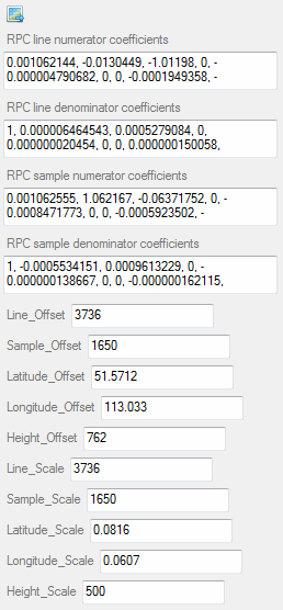
Enter parameters for an RPC spatial reference. |
|
Keywords |
None |
|
Example |
|
|
Return Value |
An ENVIRPCRasterSpatialRef object, for example: ENVIRPCRASTERSPATIALREF <437975> COORD_SYS_CODE = 0 COORD_SYS_STR = 'GEOGCS["GCS_WGS_1984", DATUM["D_WGS_1984", SPHEROID["WGS_1984",6378137.0,298.257223563]], PRIMEM["Greenwich",0.0], UNIT["Degree",0.0174532925199433]]' RPC_LINE_DEN_COEFF = 1.0000000, 6.4645428e-006, 0.00052790839, 0.00000000, ... RPC_LINE_NUM_COEFF = 0.0010621439, -0.013044900, -1.0119801, 0.00000000, ... RPC_OFFSETS = 3736.0000, 1650.0000, 51.571200, 113.03300, 762.00000 RPC_SAMP_DEN_COEFF = 1.0000000, -0.00055341510, 0.00096132292, 0.00000000, ... RPC_SAMP_NUM_COEFF = 0.0010625550, 1.0621670, -0.063717522, 0.00000000, ... RPC_SCALES = 3736.0000, 1650.0000, 0.081600000, 0.060700000, 500.00000 |
|
Type |
|
|
Description |
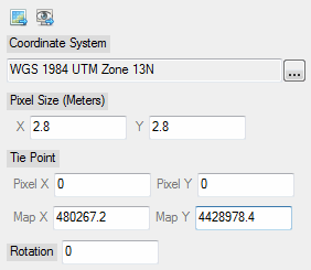
Enter parameters for a standard spatial reference. |
|
Keywords |
None |
|
Example |
|
|
Return Value |
An ENVIStandardRasterSpatialRef object, for example: ENVISTANDARDRASTERSPATIALREF <381116> COORD_SYS_CODE = 0 COORD_SYS_STR = 'PROJCS["UTM_Zone_13N", GEOGCS["GCS_WGS_1984", DATUM["D_WGS_1984", SPHEROID["WGS_1984",6378137.0,298.257223563]], PRIMEM["Greenwich",0.0], UNIT["Degree",0.0174532925199433]], PROJECTION["Transverse_Mercator"], PARAMETER["False_Easting",500000.0], PARAMETER["False_Northing",0.0], PARAMETER["Central_Meridian",-105.0], PARAMETER["Scale_Factor",0.9996], PARAMETER["Latitude_Of_Origin",0.0], UNIT["Meter",1.0]]' PIXEL_SIZE = 2.8000000, 2.8000000 ROTATION = 0.00000000 TIE_POINT_MAP = 480267.20, 4428978.4 TIE_POINT_PIXEL = 0.00000000, 0.00000000 |
|
Type |
|
|
Description |
Select an ENVI tie point file. The header in this file must reference the locations of two input rasters. |
|
Keywords |
None |
|
Example |
Use this dialog to select an ENVI tie point file ( |
|
Return Value |
An ENVITiePointSet object, for example: URI = C:\MyData\SampleTiePoints.pts INPUT_RASTER1 = <ObjHeapVar332386(ENVIRASTER)> INPUT_RASTER2 = <ObjHeapVar333409(ENVIRASTER)>
Total Tie Points: 104 0: { 229.994797 1078.083374 502.200623 817.015991 } 1: { 939.005188 283.916656 932.200623 326.640991 } etc... |
|
Type |
|
|
Description |
Enter the acquisition date and time for a dataset. |
|
Keywords |
None |
|
Example |
|
|
Return Value |
An ENVITime object, for example: ENVITIME <437990> ACQUISITION = '2016-08-04T12:18:23Z' UNIX_MILLISECONDS = 1470313103000 UNIX_SECONDS = 1470313103 |
|
Type |
|
|
Description |
This is similar to ENVITime_UI but is meant for capturing an acquisition time string. |
|
Keywords |
None |
|
Example |
|
|
Return Value |
An acquisition time string, for example: 2016-08-04T12:20:09Z |
|
Type |
|
|
Description |
This is similar to ENVITime_UI but has a wheel control to reduce the number of clicks. |
|
Keywords |
None |
|
Example |
|
|
Return Value |
An ENVITime object, for example: ENVITIME <444818> ACQUISITION = '1995-01-15T21:00:00Z' UNIX_MILLISECONDS = 790203600000 UNIX_SECONDS = 790203600 |
|
Type |
|
|
Description |
Select a file and record its uniform resource indicator (URI). The URI contains the full path and filename for the selected file. |
|
Keywords |
FILTER: Set this keyword to allow filtering of file types. MULTIPLE: Set this keyword to allow the user to select more than one file. |
|
Example |
Example with MULTIPLE keyword set:
|
|
Return Value |
A URI string or an array of URI strings, for example: C:\Data\envi.json |
|
Type |
|
|
Description |
Select a supported vector file. |
|
Keywords |
MULTIPLE: Set this keyword to allow the user to select more than one vector file. |
|
Example |
Example with the MULTIPLE keyword set:
|
|
Return Value |
An ENVIVector object or array of ENVIVector objects, for example: ENVIVECTOR <568229> AUXILIARY_URI = <Array[6]> COORD_SYS = <ObjHeapVar568250(ENVICOORDSYS)> DATA_RANGE = -158.17646, 19.702482, -68.783012, 64.848302 RECORD_TYPE = 'Point' URI = 'INSTALL_DIR\ENVIxx\classic\data\vector\cities.shp' |
IDL Elements
The following are generic UI elements that map to other IDL variable types.
|
Type |
|
|
Description |
Select any number of strings from a list. |
|
Keywords |
OPTIONS: Set this keyword to a string array with the options to display in the list. |
|
Example |
|
|
Return Value |
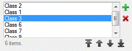
A string array of items in the list, for example: Unclassified Class 1 Class 2 Class 3 |
|
Type |
|
|
Description |
This is similar to AddRemoveList_UI but also lets the user reorder selected items. |
|
Keywords |
OPTIONS: Set this keyword to a string array with the options to display in the list. |
|
Example |
|
|
Return Value |
A string array of items in the list, for example: Unclassified Class 1 Class 2 Class 3 |
|
Type |
|
|
Description |
Select to perform an action or not. |
|
Keywords |
LABEL_0: Set this keyword to a string label for the first option. LABEL_1: Set this keyword to a string label for the second option. |
|
Example |
|
|
Return Value |
Returns a Boolean value of |
|
Type |
|
|
Description |
Define a bounding box using latitude/longitude coordinates. |
|
Keywords |
None |
|
Example |
|
|
Return Value |
A double-precision, four-element array of coordinates, for example: -111.0078 23.686523 -102.802132 39.339024 |
|
Type |
|
|
Description |
Create a set of buttons for the user to choose from. The buttons are non-exclusive (multiple items can be selected). |
|
Keywords |
COLUMN: Set this keyword to OPTIONS: Set this keyword to an array with the options to display. |
|
Example |
|
|
Return Value |
An array with the selected items. |
|
Type |
|
|
Description |
Edit the colors of pre-defined classes. |
|
Keywords |
Option 1: Set the OPTIONS keyword to strings with class names, and set the VALUE keyword to RGB color triplet values. Option 2 (shown below): Set the VALUE keyword to a hash with class names for the keys and RGB color triplets for the values. |
|
Example |
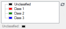
a = ORDEREDHASH( $ 'Unclassified', [0b, 0, 0], $ 'Class 1', [255b, 0, 0], $ 'Class 2', [0b, 255, 0], $ 'Class 3', [0b, 0, 255]) result = UI.CreateFromDialog(IDLColorEditTree_UI(value=a))
|
|
Return Value |
A (3, n) byte array with RGB color triplets of each class, for example: 0 0 0 255 0 0 0 255 0 0 0 255 |
|
Type |
|
|
Description |
Choose a standard or custom color. |
|
Keywords |
None |
|
Example |
|
|
Return Value |
A three-element byte array that represents an RBB color triplet, for example: 150 6 220 |
|
Type |
|
|
Description |
Choose a color table using radio buttons. |
|
Keywords |
None |
|
Example |
|
|
Return Value |
A string with the name of a color table, for example: Blue-Red |
|
Type |
|
|
Description |
Enter a complex or double-complex number (with real and imaginary components). |
|
Keywords |
None |
|
Example |
|
|
Return Value |
A complex or double-complex array with real and imaginary components, for example: ( -1.5000000, 3.5000000) |
|
Type |
|
|
Description |
This is a container that holds multiple UI classes so that they can be displayed at once (for example, in a workflow). |
|
Keywords |
CAN_TOGGLE: Set this keyword to display a check box that lets users choose to show or hide groups of smaller UI classes. See IDLContainer_UI Examples. COLUMN: Set this keyword to place all UI classes in one column. FRAME: Set this keyword to put a frame around the container. ROW: Set this keyword to place all UI classes in one row. TOGGLE_LABEL: Set this keyword to a string with a label for a group of UI classes, when the CAN_TOGGLE keyword is set. The default value is "Show Parameters." |
|
Example |
See IDLContainer_UI Examples. Also see the workflow examples in Custom User Interface Classes. |
|
Return Value |
An instance of the IDLContainer_UI class: { "raster": "<ObjHeapVar240325(ENVIRASTER_UI)>", "vector": "<ObjHeapVar240337(ENVIVECTOR_UI)>" } |
|
Type |
|
|
Description |
Select an option from a drop-down list. |
|
Keywords |
OPTIONS: Set this keyword to a string array with the options to display in the list. |
|
Example |
|
|
Return Value |
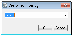
A string with the selected value, for example: Water |
|
Type |
|
|
Description |
Select an option from a drop-down list, or enter a different option by typing it. |
|
Keywords |
OPTIONS: Set this keyword to a string array with the options to display in the list. REMEMBER_VALUES_ID: Set this keyword to a string with a unique identifier for saving previous values selected by the user (up to a maximum of 15). These values will populate the drop-down list the next time this UI class is used, as long as it is created with the same string in the REMEMBER_VALUES_ID keyword. |
|
Example |
|
|
Return Value |
A string with the selected value, for example: Water |
|
Type |
|
|
Description |
Edit the items in a list. |
|
Keywords |
OPTIONS: Set this keyword to a string array with the options to display in the list. |
|
Example |
|
|
Return Value |
A string array with the updated list, for example: Band 1 Band 2 Band 3 Band 466 Band 5 |
|
Type |
|
|
Description |
Use this class to hide parameters in a custom task. |
|
Keywords |
None |
|
Example |
PARAMETER |
|
Return Value |
A value of |
|
Type |
|
|
Description |
Define a kernel array for filtering operations. |
|
Keywords |
TYPE: Specify an IDL numeric data type: |
|
Example |
|
|
Return Value |
An array [columns, rows] representing the kernel, for example: 1 1 1 1 1 1 1 1 1 |
|
Type |
|
|
Description |
Use this with custom tasks only. Enter a text label that cannot be edited. For example, display the name of an input raster that the user cannot change. |
|
Keywords |
None |
|
Example |
|
|
Return Value |
The text label, for example: qb_boulder_msi |
|
Type |
|
|
Description |
Create a list of options for a user to select, either individually or more than one using the Ctrl or Shift key. |
|
Keywords |
MULTIPLE: Set this keyword to OPTIONS: Set this keyword to a string array with the options to display in the list. |
|
Example |
|
|
Return Value |
A string array with the selected items, for example: Band 1 Band 3 |
|
Type |
|
|
Description |
Enter multiple strings. |
|
Keywords |
None |
|
Example |
|
|
Return Value |
A string array, for example: Demo QuickBird 2 data courtesy DigitalGlobe, Inc. Not for commerical use. |
|
Type |
|
|
Description |
Enter a numeric value. |
|
Keywords |
TYPE: Specify an IDL numeric data type: |
|
Example |
|
|
Return Value |
The numeric value, for example: 10.002000 |
|
Type |
|
|
Description |
Define the number of columns and rows for a raster. |
|
Keywords |
None |
|
Example |
|
|
Return Value |
A two-element integer array, for example: 123 234 |
|
Type |
|
|
Description |
Enter a pair of numeric values. |
|
Keywords |
TYPE: Specify an IDL numeric data type: LABEL_1: Set this keyword to a string label for the first field. LABEL_2: Set this keyword to a string label for the second field. COLUMN: Set this keyword to display the pair in a column. The default is to display them in a row. |
|
Example |
pair = numericpair_UI(TYPE='double', LABEL_1='Gain', LABEL_2='Offset', COLUMN=2)
|
|
Return Value |
A two-element array of numeric values, for example: 0.0010000000000000000 0.00000000000000000 |
|
Type |
|
|
Description |
Create an IDL hash or ordered hash with values that the user can edit. |
|
Keywords |
None |
|
Example |
Example of an unordered hash: h = HASH( $ "Band 1", 405.0, $ "Band 2", 520.0, $ "Band 3", 690.0, $ "Band 4", 1273.0) result = UI.CreateFromDialog(IDLHash_UI(value=h))
Example of an ordered hash: h = ORDEREDHASH( $ "Band 1", 405.0, $ "Band 2", 520.0, $ "Band 3", 690.0, $ "Band 4", 1273.0) result = UI.CreateFromDialog(IDLOrderedHash_UI(value=h))
|
|
Return Value |
The hash key/value pairs, for example: { "Band 1": 405.00000, "Band 2": 520.00000, "Band 3": 690.00000, "Band 4": 1270.0000 } |
|
Type |
|
|
Description |
Display a dialog for entering a password with hidden characters. |
|
Keywords |
None |
|
Example |
|
|
Return Value |
A string with the entered password. |
|
Type |
|
|
Description |
Create a set of buttons for the user to choose from. The buttons are exclusive (only one item can be selected). |
|
Keywords |
COLUMN: Set this keyword to OPTIONS: Set this keyword to an array with the options to display. |
|
Example |
|
|
Return Value |
A scalar with the selected item. |
|
Type |
|
|
Description |
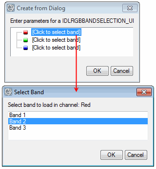
Select which bands to assign to red, green, and blue. |
|
Keywords |
OPTIONS: Set this keyword to a string array of band names. |
|
Example |
|
|
Return Value |
A long array with the selected bands, for example: 2 1 3 |
|
Type |
|
|
Description |
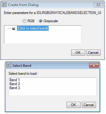
Similar to IDLRGBBandSelection_UI but also provides a Grayscale option. |
|
Keywords |
OPTIONS: Set this keyword to a string array of band names. |
|
Example |
|
|
Return Value |
An array of the selected bands, for example: 1 |
|
Type |
|
|
Description |
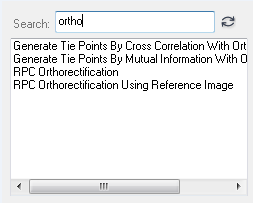
Create a list of options for a user to select, either individually or more than one using the Ctrl or Shift key. The UI contains a search box to filter the items in the list. This is useful when the list contains a large number of items. |
|
Keywords |
MULTIPLE: Set this keyword to OPTIONS: Set this keyword to a string array with the options to display in the list. |
|
Example |
|
|
Return Value |
A string array with the selected items, for example: Generate Tie Points By Cross Correlation... Generate Tie Points By Mutual Information... RPC Orthorectification RPC Orthorectification Using Reference Image |
|
Type |
|
|
Description |
Use a slider to select a numeric value. Set the MAX and MIN properties in the parameter that is associated with this UI element. |
|
Keywords |
INCREMENT: Set this keyword to the increment value of the slider. |
|
Example |
|
|
Return Value |
A floating-point value, for example: 231.000000 |
|
Type |
|
|
Description |
Enter a text string. |
|
Keywords |
None |
|
Example |
|
|
Return Value |
A text string, for example: Enter text here |
|
Type |
|
|
Description |
Enter X and Y pixel or map coordinates that define a spatial subset. |
|
Keywords |
LABEL_X: Set this keyword to a string for the X coordinate label. LABEL_Y: Set this keyword to a string for the Y coordinate label. TYPE: Set this keyword to a string with the IDL data type of the coordinates (for example, |
|
Example |
|
|
Return Value |
A numeric array of coordinate values, for example: 512 512 1024 1024 |
|
Type |
|
|
Description |
Create a list of options for a user to select, either individually or more than one using the Ctrl or Shift key. |
|
Keywords |
OPTIONS: Set this keyword to a string array with the options to display in the tree. MULTIPLE: Set this keyword to allow the user to select more than one item in the tree. |
|
Example |
|
|
Return Value |
A string or string array of the selected items, for example: Band 1 Band 3 |
|
Type |
|
|
Description |
Use a wheel control to select a numeric value. |
|
Keywords |
None |
|
Example |
|
|
Return Value |
A floating-point value, for example: 3.0000000 |


