|
<< Click to Display Table of Contents >> Shape Combination |
  
|
Shape Combination
|
<< Click to Display Table of Contents >> Shape Combination |
|
Purpose
Shape Combination tool allow users to compute the displacement decomposition of time series or compute the merging of time series in shapefile format.
The Displacement Decomposition option calculates the vertical, east-west and optionally north-south components for both the displacement time series and average velocity. For 2D decomposition, more than one stacking displacement series are needed over the same area of interest. For 3D decomposition (2D+1D, 1D+2D) more than two stacking displacement series are needed over the same area of interest.
The Merging option calculates both the merged time series and the merged average velocity. At least two stacking displacement series are needed over the same area of interest with at least the same LOS angle.
Technical Note
Displacement Decomposition option
The Displacement Decomposition option exploits displacement measurements obtained from different acquisition geometries to retrieve the displacement components along east-west, vertical and optionally north-south. This tool can deal with geocoded DInSAR displacement series only (in shape format). The resulting decomposed series cover the common time span of the ingested series, without any bias (starts from 0).
Minimum input data requirements for 2D decomposition options are:
- 1 Ascending and 1 Descending geometry measurements (best option);
- 2 Ascending or 2 Descending (the Line of Sight incidence angle of the input geometries have to differ at least 10°, as for example, near-range and far-range over the same area of interest).
Minimum input data requirements for 3D (2D+1D) decomposition options are:
- 1 Ascending and 2 Descending geometry measurements (best option);
- 2 Ascending and 1 Descending geometry measurements (best option);
- 3 Ascending or 3 Descending (the Line of Sight incidence angle of the input geometries have to differ at least 10°, as for example, near-range, medium-range and far-range over the same area of interest).
In order to obtain a more reliable decomposition result, a higher number of input are suggested, since the decomposition kernel applies a weighted least-square inversion. The weights are derived from the LOS displacement precision.
Please note: only shapefiles generated from stacking processing (PS and SBAS) are accepted. These files have to be kept in the original folder where they are created during the stacking processing, since the shapefiles are spitted in parts and the software automatically regroup them.
Sign convention:
•vertical direction: positive values upward, negative values downward;
•east-west direction: positive values eastward, negative values westward;
•north-south direction: positive value northward, negative value southward.
Please note: the north-south component accuracy is limited due to the geometrical acquisition of SAR data, with respect to east-west and vertical direction.
Basic input DInSAR measurement configuration for 2D decomposition (figure 1 below).
Optional higher redundancy input DInSAR measurement configuration for 2D and 3D decomposition (figure 2 below).
Each displacement measure is fully described by the magnitude and the angles (azimuth and inclination) of the satellite Line Of Sight.
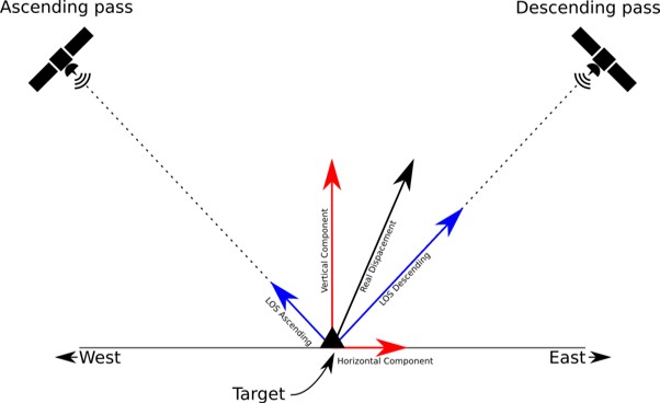
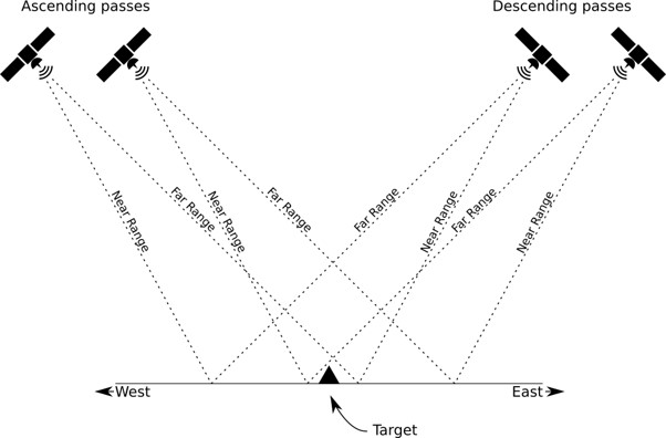
Figure 1 Basic input DInSAR measurement configuration for 2D decomposition Figure 2: Optional higher redundancy input DInSAR measurement configuration for 2D and 3D decomposition.
Merging option
The Merging option exploits displacement measurements obtained from the same acquisition geometries to retrieve the displacement merged time-series. This tool can deal with geocoded DInSAR displacement series only (in shape format). The resulting merged series cover the total time span of the ingested series (from the start time of the first time series till the end time of the last time series), without any bias (starts from 0).
Minimum input data requirement for the Merging option is 2 Ascending or 2 Descending (the Line of Sight incidence angles of the input geometries have to be the same geometry).
Please consider that to obtain a reliable result, a similar incidence angle has to be considered.
Please note: only shapefiles generated from stacking processing (PS and SBAS) are accepted. These files have to be kept in the original folder where they are created during the stacking processing, since the shapefiles are spitted in parts and the software automatically regroup them.
The average velocity estimation is computed as a linear regression of the merged time series.
The resulting combined series (decomposed or merged) cover an area defined by the intersection of the input covered areas. The output resulting points are those ones that respect the following constrain, a point per input is included in a circular area, where the radius is the defined by the user and the resulting point location is the input center of gravity.
Results from different sensor are supported.
Input Files
Input Shape Files
File name of the series of displacements shapefile (.shp) characterized by the same root name (derived by the geocoding threshold). To have a complete result coverage, all the shapefile parts have to be included (SI_XX*_Y.shp or PS_XX_Y.shp for the Y elements) These files is mandatory.
Principal Parameters
Radius:
Radius related to the points associable maximum distance constrain.
Radius Search Dimension
It defines the dimensionality (2D or 3D) for a valid radius constrain. A 3D selection is suggested for a very precise input point location derived from PS processing.
Max Point in Shape
If values other than -1 are entered, the output shape file is split in several parts (each marked by a progressive numbering - _01; _02; etc.); each part of the shape contains a portion of the total number of points, which corresponds to the value entered. It is suggested not to exceed 100000 points in order to avoid visualization problems.
Combination Type:
DECOMPOSITION_2D: decomposition time series in vertical and east-west directions.
DECOMPOSITION_2D_1D: decomposition time series in vertical and east-west directions (2D), and north-south direction (1D).
MERGE: merging of time series.
Output Files
Output Root Name
Name of the output root. This file is mandatory.
Displacement Decomposition option
_decomposed_east.shp
Shapefile including the time series of displacements component, average velocity and ancillary info along the East-West direction.
_decomposed_vertical.shp
Shapefile including the time series of displacements component, average velocity and ancillary info along the vertical direction.
_decomposed_north.shp
Shapefile including the time series of displacements component, average velocity and ancillary info along the vertical direction, in case the 3D (2D+1D) is used.
Merging option
_merge.shp
Shapefile including the time series of merged displacements component along common LOS.
Details specific to the Units of Measure and Nomenclature of the output products can be found in the Data Format section.
Please, consider that the output time series sampling rate includes the time sampling of the all input in the selected time span. In case of multi acquisition per day, one time sampling is selected as shape field.
General Functions
Exec
The processing step is executed.
Store Batch
The processing step is stored in the batch list. The Batch Browser button allows to load the batch processing list.
Close
The window will be closed.
Help
Specific help document section.
Specific Function(s)
None.
References
Fialko Y., Simons M., 2001. The complete (3-D) surface displacement in the epicentral area of the 1999 Mw 7.1 Hector Mine earthquake, California, from space geodetic observations. Geophysical Research Letters, vol. 28, no 16, pp 3063-3066.
Ng, Alex Hay-Man, et al. "Deformation mapping in three dimensions for underground mining using InSAR–Southern highland coalfield in New South Wales, Australia." International Journal of Remote Sensing 32.22 (2011): 7227-7256.